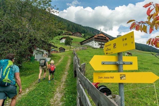
The second stage of the farmland trail leads from Kartitsch out onto the “sunny side” towards Innerlerch and then up along the edge of the woodland towards the Kartitsch Saddle. Here the route leads through picturesque larch meadows – shrewdly arranged cultivated land with a dual purpose: to provide larch timber and pasture in the same area. From here, the path follows the course of the “alter Kirchsteig” or old church path past the Äußerst, the old Prünster farms, before it continues into the forest and heads towards Obertilliach. Passing through the village of Rodarm, you reach the centre of “Obertillga” village with its tightly packed group of old smallholdings.
On reservation, visits to the farms of Joasa Hof, Innerbach (Klammerwirt) in Kartitsch and Niescherhof, Oswalderhof, Dietricher and Messenhof in Obertilliach are possible on this stage of the hike.
Financed by the European Union, the Regional Development Fund and Interreg V-A Italy-Austria 2014-2020.
Detail:
The second stage starts in the village centre of Kartitsch outside the municipal office. After the Dolomitenhof inn we turn left off the main road and follow a first asphalted and then gravelled slightly uphill road to the "Sonnseite". At Unterjakober farm we reach an asphalt road, where we turn right and follow the road for about 80 metres. We pass the "Zwischen den Straßen" field, which is cultivated by the Joasa farm. The Joasa farm itself is another approx. 150 metres straight ahead. In the direction of Obertilliach, however, we take a sharp left immediately after the Oberjakober Hof farm garden onto a meadow path that takes us uphill along a wooden fence. We pass the impressive Unteregg farm; after another 200 metres further uphill we reach a dip and another asphalt road, which we follow to the left. After another 200 metres we take a sharp right onto a forest climb. Soon the path takes us along the upper edge of the meadow beside the forest; from here, through some larches, there is a beautiful view of the farms of Kartitsch and the Karnischer Kamm ridge in the background. Above the Innerlerch farm, the path crosses a meadow that takes us to an ash tree on a gravel path, which we follow uphill. As soon as we are back in the forest we keep right at the first turn-off and follow a forest road for about 1.5 km. Before we reach the half-open areas of the larch meadows above Kartitsch Saddle, we can take a detour right back downhill to the Klammerwirt in Rauchenbach and stop off for a bite to eat (signposted, approx. 500 m, about a 10-minute walk).
We continue through the larch meadows above Kartitsch Saddle. From here we can look down into the so-called "Tannwiesen" meadows at the top of the pass, one of the most notable bog meadows in East Tyrol. We continue to follow the course of this historic thoroughfare, which always follows or takes us through the well-kept larch meadows.
Just before we reach another asphalt road, we pass the Mühlenbach shack and the Mühlenbach hayrack. The "Roggla", wooden frames for hay drying on the field, are stored in the shack. We reach the asphalt road and follow it to the Äußerst farms. Here begins a meadow path that crosses a small stream after 150 m. At this point we leave the municipal area of Kartitsch and are now in the region of Obertilliach. At the first barn, which we pass shortly afterwards, you can already see the first roofs of the "Obertillga" farms in the distance. The meadow path then continues slightly downhill and meets an asphalt road in a bend, which we follow downwards. Just before the Mitter-Prünster farm we turn sharp left onto a path through the meadows. We then reach the Main Road, which we will follow for approx. 150 Metes and then turn right, slightly downwards. We then follow unpaved forest roads through the woods, until we reach the Obertilliach Nordic Skiing & Biathlon center. We first cross the "Gail" stream and then follow through the athlete's facility, until we again reach the Main Road. Here, we turn right, an just before the "Lahnbach" Bridge, we turn left again, up into the forest. At the following crossing, we turn right and onto the "Kirchsteig". We then cross the Lahnbach stream on a wooden bridge shortly thereafter and then continue on the Obertilliacher Kirchsteig along the edge of the forest. We reach the first (uninhabited) house, turn right and walk downhill to the Rodarm village. Immediately after a small free-standing barn in the centre of Rodarm we turn left and, after the last houses, cross a wide wooden bridge. We follow the asphalted village road past the Family-Alm hotel and then directly into the village centre of Obertilliach, our destination of this stage. In the village centre we find Anja and Roland Ebner's Niescherhof farm, Maria and Harald Mitterdorfer's Messenbacherhof farm and Hans and Viktoria Obererlacher's Oswalderhof farm as well as Helmut Egarter, the night guard of Obertilliach.


