Figerhorn

The local mountain for the people of Kals!

The most important at a glance

distance
6.5 km
altitude meters uphill
🔋
807 m
altitude meters downhill
🔋
811 m
walking time uphill
3 h
walking time downhill
3 h
total walking time
6 h
highest point
🞍
2743 m
difficulty
🞽
difficult
fitness:

* * * * *

🞙🞙🞙🞙🞙

technique:

* * * * *

🞙🞙🞙🞙🞙

starting point:
Parkplatz Lucknerhaus
destination point:
Figerhorn
best season:
MAY, JUN, JUL, AUG, SEP, OCT

arrival

Parking spot

Parking area Glocknerwinkel

altitude profile

Pdf file

Gpx file

Interactive map

Current weather conditions

Schnee-01-02-03.png

0°C/32°F °C

Description

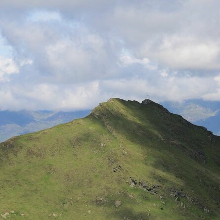
Drive up to Lucknerhaus in Kals am Großglockner. Left, next to Lucknerhaus, we start on the ‘Wendelin-Weingartner-Weg’ heading for Figerhorn. After a few serpentine bends through the area which is steep at first you get to ‘Greiwiesen’. The route flattens out, continuing to ‘Greil Bühel’. Walk in a northerly direction, along the path to the flanks of the summit of the Figerhorn. To finish, scale the final metres high above the ridge, and head towards the wonderful summit cross! The fantastic view to the Großglockner and the other mountains in the panorama is a particular highlight of this tour.

Newsletter

Subscribe to our newsletter and receive the best tips every month for current offers, mountain tours, events and much more.